Autodesk Civil 3D is an all-in-one software tool for civil engineering and infrastructure design. It blends
traditional technical design tools with BIM capabilities to provide efficient and precise design, analysis,
and documentation of civil engineering projects. Survey data management is a significant application of Autodesk Civil 3D. The software includes tools for importing and processing survey data, allowing
users to build complex survey databases and incorporate the information into the design process. This allows for more accurate alignment layouts, earthwork calculations, and existing condition analyses. Geospatial analysis and data integration are also available in Civil 3D. Geospatial data, such as aerial
images, topographic maps, and GIS data, can be used to aid in the study and visualization of project
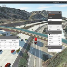
sites. This integration allows for better decision-making during the design process and improves overall project accuracy. Road and highway design is another important application of Civil 3D. The software allows you to create road networks by creating alignments, profiles, and corridors. Dynamic
3D models of road alignments, including complex intersections and roundabouts, can be generated
by users and analyze the movement using vehicle tracking.
INSTRUCTORS:

GAPFIZI Pierre
ASSISTANT TRAINER / CIVIL AND INFRASTRUCTURE DEPARTMENT
Civil 3D also makes it easier to create grading solutions for sites and platforms, such as earthwork calculations and cut/fill analysis. It can help you build and analyze pipe networks for utility infrastructure, such as stormwater management systems and sanitary sewers. The software allows you to create and change pipe networks, perform hydraulic calculations, and generate reports. It enables engineers to design and analyze pipe network layout, size, and capacity for efficient and effective infrastructure systems.
Civil 3D’s BIM capabilities enable collaborative design and documentation. Multiple team members can collaborate on a project at the same time, discussing design changes and updates in real-time. The software also provides construction documentation generation features like plan and profile sheets, cross-sections, and volume calculations. These capabilities help to speed up the documentation process and ensure that stakeholders receive reliable information.
What you will learn:
Upon completion of this training, participants will:
1. Gain in-depth knowledge of Autodesk Civil 3D, enhancing your proficiency in utilizing its
features and tools for civil engineering projects.
2. Learn effective project workflows, allowing you to navigate seamlessly through the software and streamline your design processes.
3. Obtain a valuable skill set sought after by employers in the civil engineering and infrastructure design industry, increasing your job market competitiveness.
4. Learn to integrate site and road designs, promoting a holistic approach to civil engineering projects and enhancing overall project coordination.
5. Develop the ability to create comprehensive and professional design documentation,
improving your communication and presentation skills within the industry.
6. Position yourself for career growth by staying updated with industry-standard software and practices, making you a valuable asset to your organization.
7. Connect with fellow professionals in the training, expanding your professional network and potentially opening doors to collaboration and career opportunities.
8. Develop the skills to address complex design challenges, improving your problem-solving abilities in the context of civil engineering projects.
9. Stay current with industry trends and technologies, fostering a mindset of continuous learning and adaptability in the dynamic field of civil engineering.
Overall, participating in this training program can significantly enhance your skill set, boost your confidence in using Autodesk Civil 3D, and provide you with a competitive edge in the professional landscape.
Who should attend?
The training is designed for professionals and individuals in the civil engineering and related fields who are involved in infrastructure design and site development.
This includes:
Civil Engineers: Those involved in road design, site development, and infrastructure projects.
Land Surveyors: Professionals dealing with survey data for accurate site modeling.
Land Planners: Individuals engaged in the planning and design of land use and development.
CAD Technicians: Individuals working with Computer-Aided Design tools, seeking specialization in civil engineering applications.
Additionally, the training is designed for only professionals who have been involved in the various aspects of civil engineering and design. Especially roads and land development.